The Atlantic Basin woke up after an almost three-week slumber. After Gabrielle, we're watching another tropical wave for development. Here's the latest.
An oceanfront home in Buxton, North Carolina collapsed into the Atlantic after a coastal storm battered the Outer Banks with flooding, rain and high winds. The dramatic collapse left behind more than a mile of beach debris, marking the twelfth house lost in this way and highlighting the growing threat of shoreline erosion in the area.
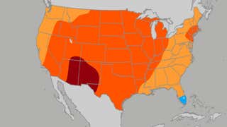
Some places could start seeing vibrant fall colors soon, while others will still have to wait a while. Here's a look at the typical progression of peak fall color across the United States.
Over the course of a year, more than 4 million tourists visit Yellowstone National Park, and many of those folks leave the park with less than they arrive with. Thousands of pieces of junk are left behind, including hundreds of hats lost. Meet the crew responsible for cleaning up the park.